Last Updated: June 25, 2026 | Originally Published: October 9, 2024
- Best for views: Ulsanbawi Rock Trail — 3.8km RT, 3–4 hours, ~800m elevation gain to panoramic granite summit
- Best for families: Biryong Falls — 2.4km RT, 1–1.5 hours, easy path to an 18m waterfall
- Biggest challenge: Daecheongbong Peak — ~16km RT, 8–10 hours, South Korea’s 2nd highest peak at 1,708m
- Getting there: Express bus from Seoul‘s Dong Seoul Terminal to Sokcho (~2.5 hrs, ~₩15,800), then local Bus #7 to the park entrance (~₩1,400)
- Park admission: Free — Korea National Park Service (KNPS) abolished entry fees at all national parks in 2020
Trail Comparison: All 5 Hikes at a Glance
Choosing the right trail before you travel saves a frustrating morning reroute. This table maps distance, time, and difficulty so you can match the hike to your group.
| Trail | Distance | Time (RT) | Difficulty | Best For |
|---|---|---|---|---|
| Ulsanbawi Rock | 3.8 km | 3–4 hrs | Hard | Summit views, photos |
| Biryong Falls | 2.4 km | 1–1.5 hrs | Easy | Families, casual hikers |
| Daecheongbong Peak | ~16 km | 8–10 hrs | Expert | Peak baggers, fit hikers |
| Geumganggul Cave | 3 km | 2–3 hrs | Moderate | Culture + nature mix |
| Cheonbuldong Valley | Variable | 5–6 hrs | Moderate | Autumn foliage, waterfalls |
How to Get to Seoraksan from Seoul
Most hikers base themselves in Sokcho, a coastal city about 3km from Seoraksan’s main entrance. The standard route from Seoul takes roughly 2.5 hours.
From Dong Seoul Bus Terminal (동서울종합터미널), take an express bus to Sokcho Terminal. The terminal is connected to Gangbyeon Station on Seoul Metro Line 2. Buses depart frequently throughout the day. One-way fare is approximately ₩15,800 as of 2026.
From Sokcho Terminal, board local Bus #7 or #7-1 toward Seorakdong. The ride to the park entrance takes about 30 minutes and costs approximately ₩1,400. A taxi from Sokcho Terminal to the park entrance costs roughly ₩15,000–₩20,000 for the vehicle.
Ulsanbawi Rock Trail
Ulsanbawi is the most iconic hike in Seoraksan — six granite pillars rising sharply above the Inner Seorak ridgeline. The round trip covers 3.8km and climbs nearly 800 meters in elevation.
The trail winds through forest before reaching steep metal staircases near the summit. Most hikers finish in 3–4 hours. From the top, on clear days, you can see both the surrounding mountain ranges and the East Sea.
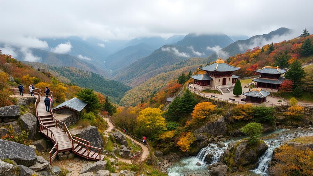
Biryong Falls Hike
Biryong — meaning “Flying Dragon” in Korean — is the most accessible trail in the park. The 2.4km path follows a wide, maintained route over wooden bridges, with no technical sections.
The falls drop 18 meters into a plunge pool. A viewing platform gives a direct angle for photos. Round trip takes 1–1.5 hours, making this an easy pairing with a second, longer trail on the same day.
Daecheongbong Peak Expedition
At 1,708m, Daecheongbong is South Korea’s second-highest peak. The most popular route from the main Seorakdong entrance covers approximately 16km round trip — one of the longest day hikes in the country.
Expect 8–10 hours on the trail. Start no later than 06:00 AM to summit and descend before dark. Upper ridge conditions change fast even in summer months.
According to the Korea National Park Service (KNPS), the Daecheongbong summit area and approach trails are subject to seasonal closures enforced by park rangers. Check the official KNPS website for current trail status before booking transport.
Geumganggul Cave Trek
The Geumganggul Cave hike begins at Sinheungsa Temple, a Buddhist temple originally founded in the 7th century (the current structure dates from 1647). The temple is worth 15–20 minutes of exploration before heading up the trail.
From Sinheungsa, the cave is 1.5km uphill via a forested path ending at metal staircases. Inside Geumganggul Cave, a small Buddha statue sits with incense. Round trip takes 2–3 hours — more accessible than Ulsanbawi with similar scenic rewards.
Cheonbuldong Valley Adventure
Cheonbuldong Valley follows a mountain stream through Inner Seorak, passing several waterfalls and crossing streams on stepping stones. The path continues past Biseondae Rock — a flat granite outcropping popular for rest stops — before climbing deeper into the valley.
Allow 5–6 hours round trip. Some sections involve steep scrambling. Autumn foliage (mid-September to late October) makes this Seoraksan’s most visually rewarding trail during that period.
Seoraksan Cable Car: Views Without the Full Climb
For visitors who want elevated views without a full hike, the Seoraksan Cable Car (설악산 케이블카) departs from the Sogongwon area near the main park entrance. The 10-minute ride climbs to a platform near Gwongeumseong Fortress ruins.
Round-trip fare: approximately ₩14,000–₩16,000 for adults as of 2026 (verify current pricing at the ticket booth — rates adjust seasonally). Operating hours run roughly 09:00–17:00, with earlier close in winter. Weekend queues can reach 40–60 minutes — purchase tickets immediately on arrival.
A short 10-minute walk from the cable car arrival point reaches the fortress ruins, with views across Inner Seorak and toward the East Sea. This pairs well with the Geumganggul Cave trek for a full half-day visit without expert-level commitment.
“Seoraksan National Park is one of South Korea’s most-visited destinations, attracting millions of hikers and nature tourists annually.” — Korea Tourism Organization (KTO)
Frequently Asked Questions
Is there an entry fee for Seoraksan National Park?
No. The Korea National Park Service (KNPS) abolished admission fees at all national parks, including Seoraksan, in 2020. The Seoraksan Cable Car charges its own fare (approximately ₩14,000–₩16,000 RT for adults) but park entry is free.
What is the best time of year to hike Seoraksan?
Mid-September to late October is ideal: cool temperatures, clear skies, and peak autumn foliage. Spring (April–May) is also excellent with blooming azaleas. The Daecheongbong summit route typically closes mid-November to late March due to ice and snow.
How difficult are the trails for beginner hikers?
Biryong Falls is genuinely beginner-friendly — flat, well-marked, and completable in under 2 hours. Geumganggul Cave is manageable for most hikers with basic fitness. Ulsanbawi and Daecheongbong require appropriate gear and preparation.
Are camping facilities available at Seoraksan?
Designated campsites require advance reservation through the KNPS portal at knps.or.kr. Wild camping outside authorized areas is prohibited. Book well in advance for autumn weekends — popular sites fill months ahead.
Is it necessary to hire a guide?
No guide is required. All major trails have Korean and English signage, and a trail map is downloadable from the KNPS website. For Daecheongbong, hiking with an experienced partner is strongly recommended given the trail length and variable summit conditions.
What wildlife might I see on the trails?
Seoraksan hosts Korean goral (a rare mountain goat-antelope), Asiatic black bears, deer, and wild boars. Birdlife on the ridgelines includes woodpeckers and birds of prey. Maintain a safe distance from all wildlife and do not feed animals.
Last updated: June 2026 | Sources: Korea National Park Service (KNPS, knps.or.kr), Korea Tourism Organization (KTO)
More on Hiking & Nature:
Written by Sam Konneh
Sam Konneh is an AI strategist and digital marketer based in Seoul, South Korea. With years spent living, working, and exploring across Korea, Japan, and China, he shares firsthand insights into East Asia's cultures, hidden gems, and everyday life. A graduate of Inha University and KDI Graduate School, Sam combines data-driven expertise with on-the-ground experience. His journey also includes studying in Malaysia and traveling through Southeast Asia. Through practical tips, local stories, and travel guides, he helps fellow explorers discover both the celebrated highlights and the lesser-known corners of East Asia.

